
SolarAnywhere offers industry-first, high-resolution, far-horizon shading data to accurately assess shading losses due to complex terrain near a PV site. SolarAnywhere far-shading data is generated and delivered in the form of azimuth and elevation pairs (expressed as degrees) and is available globally. These datasets can be accessed from the SolarAnywhere data website or the SolarAnywhere API, and are included with all Typical Year, Typical Year+ and Sites licenses.
Download Far-Shading Data Sample (CSV File)How to Access
SolarAnywhere far-shading datasets are currently offered through our Typical Year, Typical Year+ and Sites licenses, with access through the SolarAnywhere online data portal or SolarAnywhere API. Far-shading data is available for any licensed Typical Year, Sites or Public location. If the desired location is not currently licensed to a user, the user must purchase that site (with a Typical Year or Sites license) to access the requested far-horizon shading dataset through SolarAnywhere.
Access via the SolarAnywhere Website
Far-shading files are available from the Map interface on the SolarAnywhere data website. These files are output as valid horizon profile CSV files containing two primary columns: azimuth (degrees) and elevation (degrees).
To download a far-shading file:
- Select a location for download in the Location List or by selecting a pin on the map.
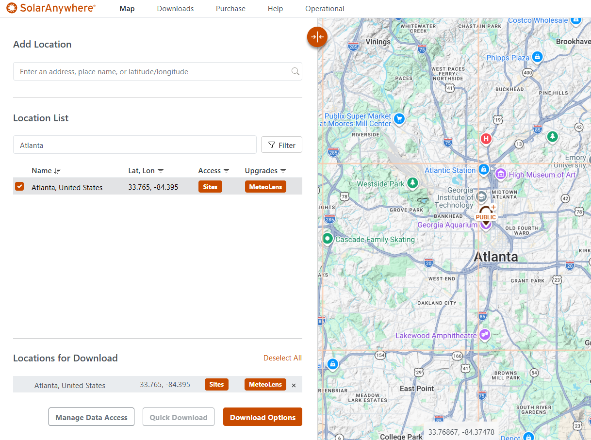
Figure 1. Selecting a Sites Location on the SolarAnywhere Data Website
- Click “Download Options.”
- Choose “Elevation (Horizon Shading)” under “Data File Types.”
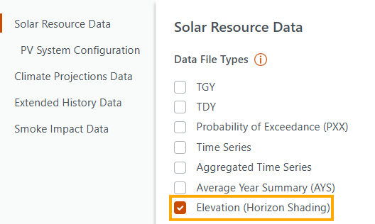
Figure 2. Elevation (Horizon Shading) settings on the SolarAnywhere Data Website
- Click “Download” and navigate to the Downloads tab to download and view the file:
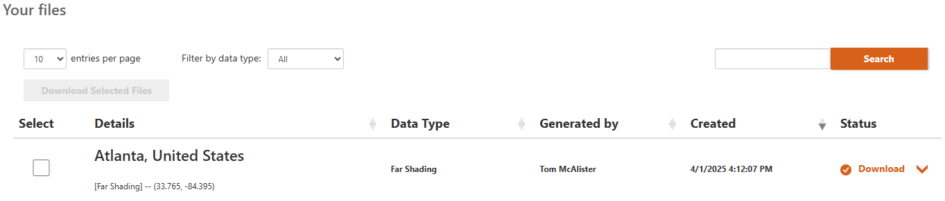
Figure 3. Downloads Tab on the SolarAnywhere Data Website
Users can demo far-shading files at select locations with SolarAnywhere Public.
Access via the SolarAnywhere API
Far-shading data can also be requested through the SolarAnywhere API. Visit this page of our API documentation to access example far-shading requests.
Far Shading Impacts on Irradiance
Solar PV projects are increasingly being built in locations with undulating terrain and proximity to hills, mountains or canyons. Nearby topographical features such as valley walls or hills can block solar irradiance from reaching PV panels, especially in the early and late hours of the day. These irradiance and PV output losses are commonly referred to as far-horizon shading losses and can range anywhere from less than 1% in estuarine wetlands, to over 12% in evergreen forests. Some studies show that direct solar irradiance can be obstructed for most of the year on certain steep mountain slopes.1
Figure 3 demonstrates the effect of horizon shading on irradiance. If the sun is below the horizon profile, the direct/beam component (Beamhorizontal) as well as the circumsolar diffuse component (DCS) are blocked entirely, whereas a fraction of the horizon brightening (DHB) and isotropic diffuse (Diso) components is blocked.
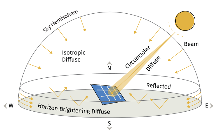
Figure 3. Effect of Horizon Shading on Irradiance
Because local terrain is unique and solar angles vary constantly, the shadows must be considered for each sun position over an hourly, daily and monthly time interval. To estimate this, a site-specific shading horizon profile must be determined for the PV system. This horizon profile data is generally in the form of azimuth and corresponding elevation pairs, and it can be used to estimate the impact of terrain undulation on the solar resource and PV output.
Methodology
SolarAnywhere offers far-shading data to support accurate PV performance modeling. The data is based on satellite observations from the NASA Advanced Spaceborne Thermal Emission and Reflection Radiometer (ASTER) dataset. The spatial resolution of this data is 30m x 30m nominal native resolution (1 arc-second resolution).
For each user-provided coordinate, the surrounding terrain is scanned at a 1-degree angular resolution. Elevation angles are calculated at multiple distances from the origin, and the largest angle is chosen as the elevation angle of the horizon.
SolarAnywhere far-shading data is available with SolarAnywhere versions 3.7 and newer in all geographic regions. All SolarAnywhere users can access this data through the SolarAnywhere data website and the API at no additional cost.
Using SolarAnywhere Far-Shading Data
A study of terrain obstruction induced losses on the island of Oahu, Hawaii, found overall reduction in total yield of about 7% across the island. To learn more about far-shading and impact on PV generation, watch the recorded presentation.
Conventional approaches to estimating horizon shading, such as use of commercial shading analysis tools and raw fisheye images, tend to overestimate the direct beam shading.2 High-resolution satellite-derived shading data enables solar developers and contractors to generate horizon profiles on-demand, saving time spent in costly on-site visits to determine far shading impacts.
In addition to obstructions farther in the horizon, SolarAnywhere far-shading data also accounts for the effect of nearby objects such as trees, buildings etc. Figure 4 shows how SolarAnywhere far-shading data accounts for near-object shading from trees at the test site when compared with PVGIS data.
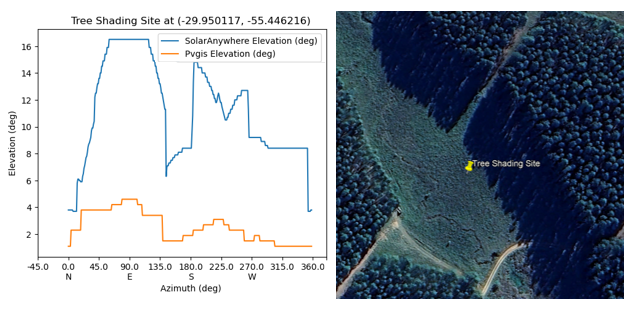
Figure 4. Comparison of SolarAnywhere and PVGIS Horizon Shading Data
SolarAnywhere far-horizon data is generated in the form of azimuth and elevation pairs for a given coordinate. Figure 5 shows the format of the far-shading output file.
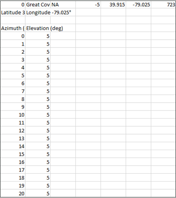
Figure 5. Far-Shading Datafile
The file can be used with third-party PV modeling tools to estimate the impact of the horizon profile on irradiance and improve the accuracy of PV performance estimates. Figure 6 shows an example of the horizon profile generated on importing SolarAnywhere far-shading data in PVsyst.
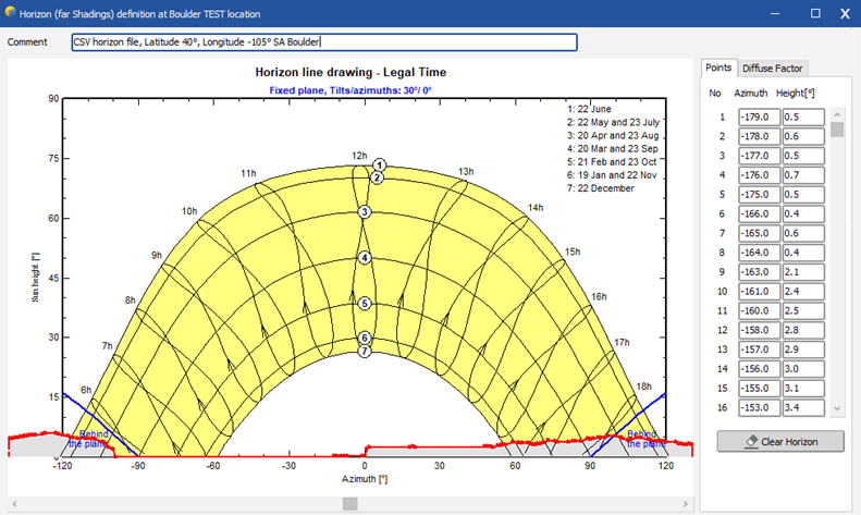
Figure 6. Horizon Profile Generated in PVsyst using SolarAnywhere Far-shading Data
For instructions on importing a SolarAnywhere a far-shading datafile into PVsyst, PlantPredict, or PVcase, please visit the following pages within the SolarAnywhere Support Center:
- Using SolarAnywhere Data in PVsyst
- Using SolarAnywhere Data in PlantPredict
- Using SolarAnywhere Data in PVcase
References
1 Aguilar C, Herrero J, Polo MJ. 2010. Topographic effects on solar radiation distribution in mountainous watersheds and their influence on reference evapotranspiration estimates at watershed scale. Hydrololy and Earth Systems Sciences, 14(12), p 2479–2494. DOI: 10.5194/hess-14-2479-2010.
2 Mira DC, Bartholomaus M, Poulsen PB, Spataru SV. 2021. Accuracy Evaluation of Horizon Shading Estimation Based on Fisheye Sky Imaging. IEEE 48th Photovoltaic Specialists Conference (PVSC). DOI: 10.1109/PVSC43889.2021.9519063. Link