SolarAnywhere data including TGY, time-series and forecast are available in the following regions
| Region | Countries Supported | Spatial Resolution1 | Temporal Resolution2 | Period Start | Period End | Notes |
|---|---|---|---|---|---|---|
| North America (Satellites: GOES-E, GOES-W) | Continental USA, Hawaii, Canada up to 60°N, Mexico, Caribbean |
1 km, 500 m |
5 min, 10 min, 30 min |
1/1/1998 | Current hour; 14 day forecast available | 10 min from 2018-present (GOES-E) and 2020-present (GOES-W). 30 min from 1998-2018. 5 min and 500m are available in CONUS only, 2020-present; Sites upgrade required. |
| South America (Satellite: GOES-E) | All | 1 km |
10 min, 90 min |
1/1/1998 | Current hour; 14 day forecast available | 10 min from 2018-present. 90 min from 1998-2018. |
| Africa & West Asia (Satellites: MFG, MSG) | All up to 60°N and 106°E |
2.5 km, 3 km |
30 min | 3/1/1999 | Current hour; 14 day forecast available | 30 min from 1999-present. |
| Europe (Satellites: MFG, MSG)3 | All up to 60°N and 23°E |
2.5 km, 1 km |
10 min, 15 min, 30 min, 60 min |
1/1/1998 | Current hour; 14 day forecast available | 10 min from 2026-present; 15 min from 2005-2026; 30 min from 1998-2005; 60 min for real-time and forecast data periods. |
| Oceania & East Asia (Satellite: Himawari) | All up to 60°N and 180°E |
1.25 km, 1 km |
10 min | 9/1/2005 | Current hour; 14 day forecast available |
1Satellite visible-light resolution. Regions with more than 1 spatial resolution were covered by satellites whose spatial resolution changed during our period of record. For consistency across geographies, data is accessed in 1km and 10km nominal, which corresponds to 0.01 or 0.1 degree grid.
2Temporal resolution indicates how often new satellite imagery is refreshed for the various sources.
310-minute native resolution in Europe currently only available for SolarAnywhere Version 4.1.
High resolution (5 minute) historical and real-time time-series data is available on demand in the contiguous U.S. (latitudes 15° to 50°, longitudes -125° to -62°) and Hawaii from 1/1/2020 and is updated at 5-minute intervals.
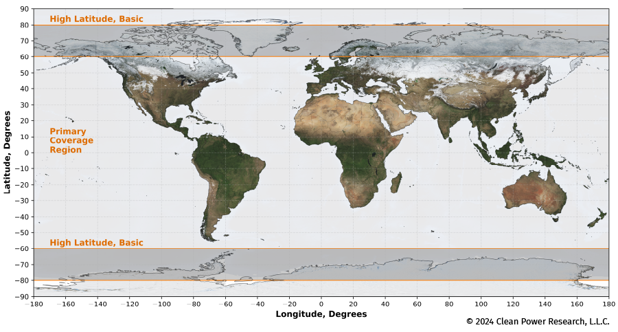
High resolution (5 minute and 1 minute) typical year data is available globally between +/-60 latitude.
SolarAnywhere High-Latitude Data
We offer basic irradiance data in high-latitude regions, covering +/-[60–80] degrees latitude. While satellite coverage of this region is available, native data resolutions are much coarser than our data within 60 degrees latitude. For more information, see our high-latitude methods and validation.
SolarAnywhere Coverage Map